
Changamwe is a sub-county in Mombasa County that was established in 2013 under Kenya’s devolved governance system. It is located in the northeastern part of Mombasa and borders Jomvu Sub-County to the north and Mvita Sub-County to the south. Changamwe’s primary postal code is 80102, covering its administrative headquarters on Pamba Road. The sub-county’s postal codes fall within the 80100–80104 range, shared with neighboring areas like Mombasa CBD (80100) and Docks (80104).
Changamwe at a Glance
| Category | Details |
|---|---|
| Year Established | 2013 |
| Parent County | Mombasa |
| Geographic Location | Northeastern Mombasa, adjacent to Port |
| Total Area (sq km) | 16.0 |
| Population (latest census) | 131,882 |
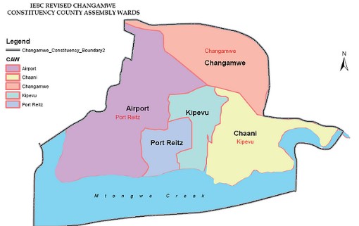
| Number of Wards | 5 |
| Number of Constituencies | 1 (Changamwe Constituency) |
Administrative Structure
Changamwe Sub-County operates under the Mombasa County Government, adhering to Kenya’s decentralized governance framework. It is governed by an appointed Sub-County Administrator overseeing public services, infrastructure, and local development.
The sub-county collaborates with the County Assembly on legislative matters and budget allocation, and has one Changamwe Constituency, represented by a Member of Parliament, which comprises five wards, each managed by elected ward representatives.
| Administrative Unit Type | Name of Unit |
|---|---|
| Constituency | Changamwe Constituency |
| Wards | Port Reitz |
| Kipevu | |
| Airport | |
| Chaani | |
| Changamwe |
Complete Changamwe Postal Code List
Below are the verified postal codes for Changamwe :
| Ward/Town/Area | Postal Code | Facility Type |
|---|---|---|
| Changamwe | 80102 | Administrative Headquarters |
| Miritini | 80102 | Industrial/Residential |
| Chaani | 80102 | Residential |
| Port Reitz | 80102 | Medical/Educational |
| Airport | 80102 | Transport/Commercial |