
Gilgil, a sub-county in Nakuru County, was established under Kenya’s 2010 Constitution after the 2013 general elections. It is located approximately 120 kilometers northwest of Nairobi. Gilgil borders Naivasha to the southeast and Nyandarua County to the east. Gilgil’s primary postal code is 20116.
Gilgil at a Glance
| Category | Details |
|---|---|
| Year Established | 2013 |
| Parent County | Nakuru |
| Geographic Location | Rift Valley Province, Northwest Nakuru, bordering Nyandarua and Naivasha |
| Total Area (sq km) | 1,075.4 |
| Population (2023 estimate) | ~240,000 (County Projection) |
| Number of Wards | 5 |
| Number of Constituencies | 1 (Gilgil Constituency) |
Administrative Structure
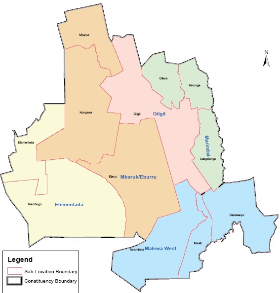
Gilgil Sub-County operates under Nakuru County’s devolved governance system, led by an elected Member of Parliament (constituency level) and a County Executive Committee member. The sub-county comprises five wards, each represented by a Member of County Assembly (MCA), focusing on local infrastructure, education, and agriculture.
| Administrative Unit Type | Name of Unit |
|---|---|
| Constituency | Gilgil |
| Wards | Gilgil Ward Ebburu/Mbaruk Ward Elementaita Ward Murindat Ward Malewa West Ward |
Complete Gilgil Postal Code List
Below are the verified postal codes for Njoro:
| Ward/Town/Area | Postal Code | Facility Type |
|---|---|---|
| Gilgil Town | 20116 | Post Office, Commercial Hub |
| Karunga | 20116 | Residential |
| Elementaita | 20119 | Tourism & Hospitality |
| Malewa West | 20116 | Agricultural Zone |
| Murindati | 20116 | Rural Settlement |
| Mbaruk Eburu | 20116 | Ecological Reserve |