

Kasarani is a Sub-County located in northeastern Nairobi County. It covers approximately 135.33 km² and borders Thika Road, Roysambu, Zimmerman, and Githurai. Kasarani was established as a formal administrative unit in 2010 following the devolution of Kenya’s government; It evolved from the larger Kasarani Constituency, which was subdivided to enhance localized governance. Kasarani’s main postal code for its headquarters is 00608, while the sub-county’s postal codes fall within Nairobi’s broader range of 00000–00999.
Kasarani at a Glance
| Year Established | Parent County | Geographic Location | Total Area (sq km) | Population (2023) | Number of Wards | Number of Constituencies |
|---|---|---|---|---|---|---|
| 2010 | Nairobi County | Northeastern Nairobi | 135.33 | 780,656 | 5 | 1 |
Administrative Structure
Kasarani Sub-County operates under the Nairobi City County Government, led by Governor Johnson Sakaja. Its governance structure includes a Sub-County Administrator overseeing day-to-day operations, public service delivery, and coordination with county departments.
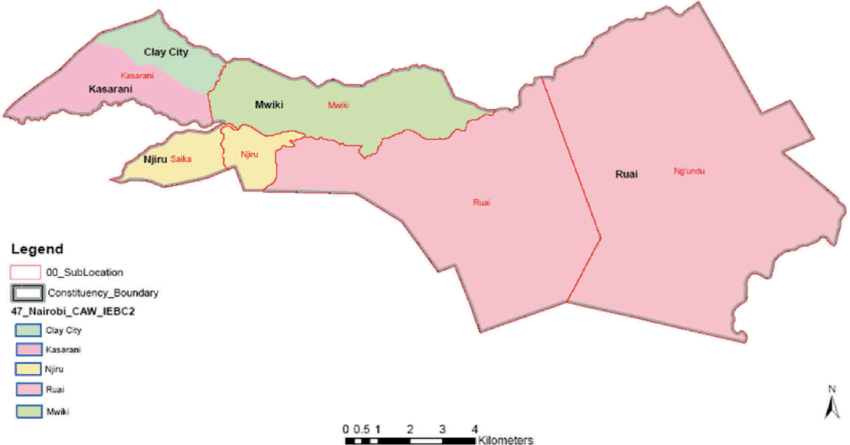
The Kasarani sub-county comprises one parliamentary constituency (Kasarani) and five electoral wards, each represented by a Member of the County Assembly (MCA). Below are the wards in Kasarani
| Administrative Unit Type | Name of Unit |
|---|---|
| Constituency | Kasarani |
| Wards | Mwiki, Kasarani, Ruai, Njiru, Clay City |
Complete Kasarani Sub-County Postal Code List
Kasarani’s postal codes follow Kenya’s five-digit format, starting with 00, indicating it is found in Nairobi County. All the Postal codes around the Kasarani region are as follows:
| Ward/Town/Area Name | Postal Code | Facility Type |
|---|---|---|
| Kasarani Headquarters | 00608 | Administrative/Post Office |
| Ruai | 00520 | Residential/Commercial |
| Mwiki | 00608 | Residential |
| Njiru | 00608 | Residential |
| Clay City | 00608 | Residential |
FAQ
Which county is Kasarani in?
Nairobi
What is the postal code of Kasarani?
00608