
How many districts are in Nairobi? Nairobi Today does not use the District system because of Kenya’s 2010 Constitution, which paved the way for a developed governance structure where Nairobi has 17 sub-counties, replacing the previous eight districts: Central Nairobi, Dagoretti, Embakasi, Kasarani, Lang’ata, Makadara, Westlands, and Pumwani, which were established during British colonial rule in Kenya.
Today, many still confuse Nairobi Districts with Nairobi sub-counties or constituencies. Districts no longer exist today as administrative units in Nairobi or any parts of Kenya. With the introduction of a developed governance structure after the 2013 general elections, the districts in Nairobi were replaced with the current sub-counties in Nairobi. On the other hand, constituencies aren’t administrative units, but are defined as political and electoral units established under Article 89 of the Constitution of Kenya, and serve as units for electing MPs and organizing representation in Parliament. Each constituency is divided into wards, the basis for electing Members of the County Assembly (MCAs).
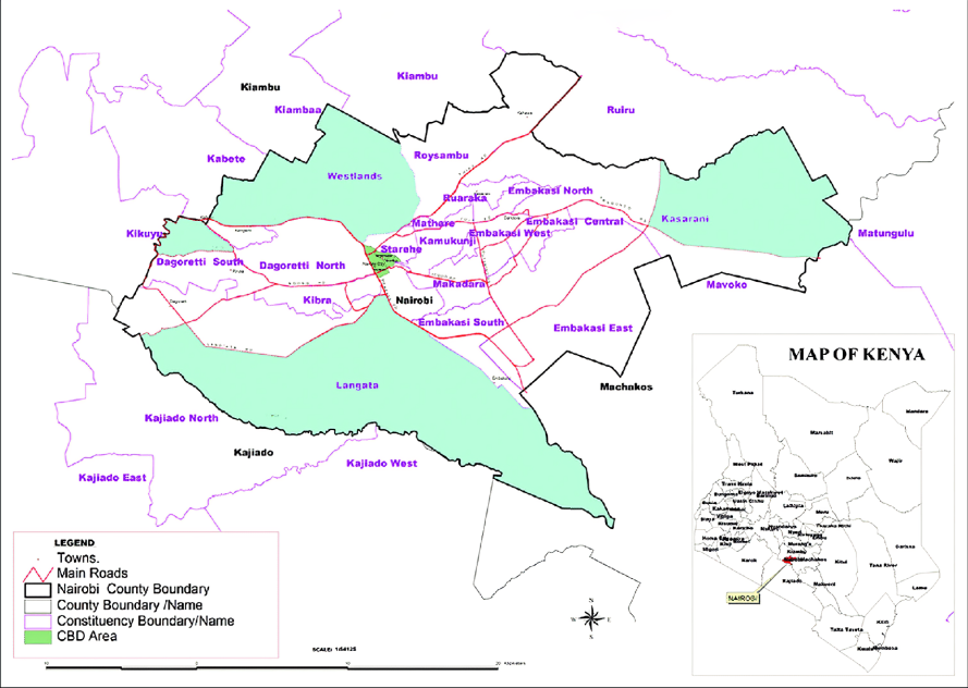
How Is Nairobi Administratively Structured?
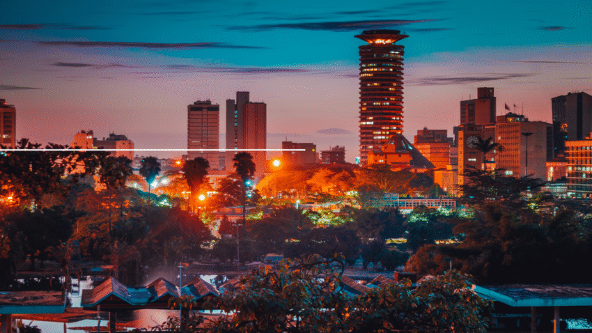
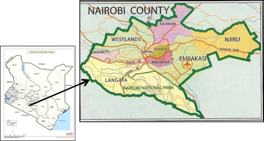
Nairobi plays many functions in the Kenyan administration. For starters, it is known as the capital and largest city of Kenya, with an estimated population of around 5,766,990 in 2025. In addition, under the 2010 Kenyan constitution, which introduced a devolved governance framework adopted in 2013, Nairobi is Kenya’s 47th county.
The Nairobi County is led by the County Governor, structured administratively in three tiers as follows:
| Level | Number | Description | Leadership |
|---|---|---|---|
| County | 1 | Overall county governance | Members of the County Assembly (MCAs) |
| Sub-Counties | 17 | Primary administrative units (e.g., Westlands, Embakasi, Langata) | Sub-county administrators |
| Constituencies | 17 | Electoral zones aligned with sub-counties | Members of Parliament (MPs) |
| Wards | 85 | Hyper-local units focusing on grassroots development | Members of County Assembly (MCAs) |
What Are the 17 Sub-Counties (Districts) of Nairobi?
Before we get into details of each Nairobi Sub County in Nairobi, if you are in a hurry, you may want to skim all the sub-counties at once by taking a look at the table below:
| No. | Sub-County (Constituency) | Population (2019) | Area (km²) (approx.) |
|---|---|---|---|
| 1 | Westlands | 308,854 | 72.4 |
| 2 | Dagoretti North | 186,222 | 29.0 |
| 3 | Dagoretti South | 247,365 | 27.0 |
| 4 | Lang’ata | 197,489 | 196.8 |
| 5 | Kibra | 185,777 | 12.1 |
| 6 | Embakasi East | 178,734 | 17.0 |
| 7 | Embakasi West | 243,898 | 18.0 |
| 8 | Embakasi Central | 208,260 | 16.0 |
| 9 | Embakasi North | 213,294 | 21.0 |
| 10 | Embakasi South | 219,220 | 12.0 |
| 11 | Kasarani | 780,656 | 152.6 |
| 12 | Ruaraka | 192,620 | 12.0 |
| 13 | Kamukunji | 268,276 | 12.0 |
| 14 | Makadara | 189,536 | 12.0 |
| 15 | Starehe | 210,423 | 20.6 |
| 16 | Mathare | 206,564 | 3.0 |
| 17 | Roysambu | 288,571 | 41.0 |
And now let us get into more specific details about each of the Nairobi District’s current areas in detail:
Westlands
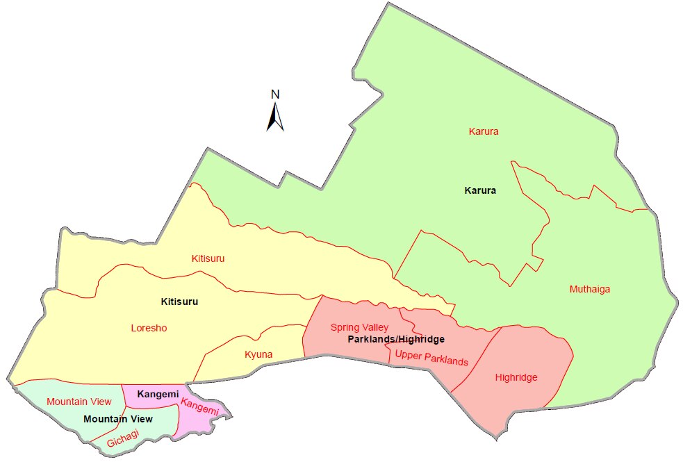
Westlands is a sub-county in Nairobi County located in the northwestern part, covering 72.4 square kilometers. It is bordered by Dagoretti North to the southwest and Kasarani to the northeast. It was initially called Nairobi Northwest Constituency in 1963 before the name was changed to Westlands in 1988. Administratively, Westlands comprises a single parliamentary constituency divided into five wards: Kitisuru, Parklands/Highridge, Karura, Kangemi, and Mountain View. The main Postal code for Westlands is 00800.
Dagoretti North
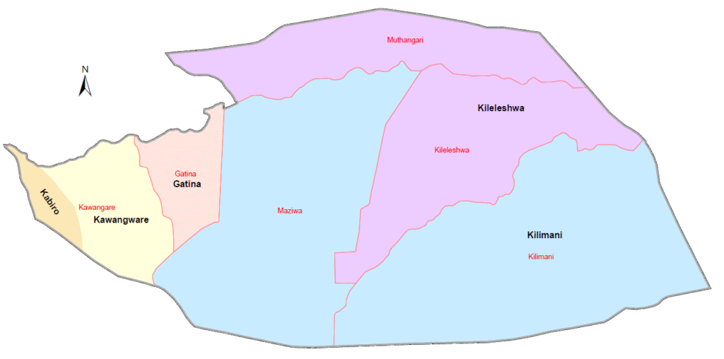
Dagoretti North is a sub-county located in the western Part of Nairobi County. It covers 29 km² and is recognized for its popular neighborhoods, such as Kawangware and Kileleshwa. Its administrative framework comprises a single parliamentary constituency divided into five wards: Kawangware, Gatina, Kileleshwa, Kilimani, and Kabiro. Dagoretti North postal code is 00603
Dagoretti South
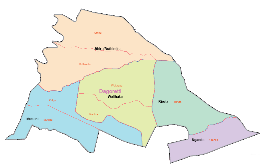
Dagoretti South is located in the southern part of Nairobi. It is bordered by Kiambu County to the west and bisected by the boundary of the Dagoretti Road Reserve. Although it was formed in 2013, it has a long history, especially after British colonial expansion in the 1890s. It was initially home to Kikuyu farmers and Maasai pastoralists. The sub-county is administratively divided into five wards: Mutu-ini, Ngando, Riruta, Uthiru, and Waithaka. The Dagoretti South postal code is 00605.
Lang’ata
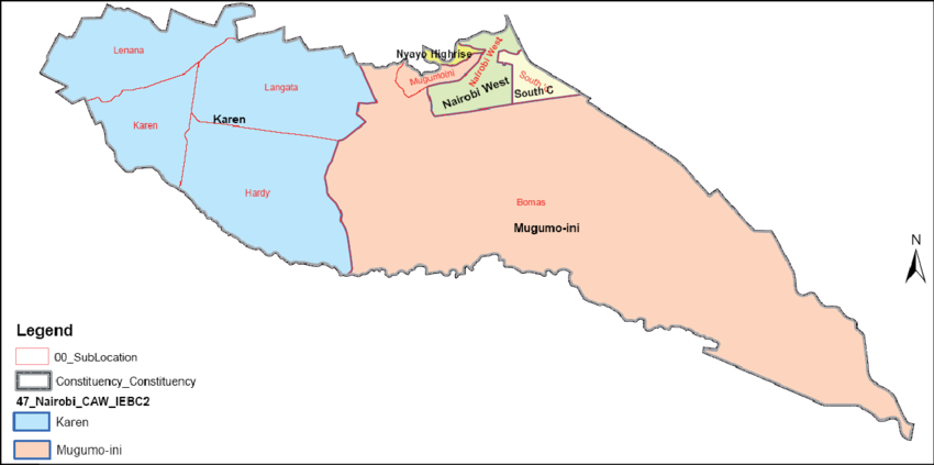
Lang’ata is located in the southwestern part of Nairobi. Its origins can be traced back to the colonial-era King’s African Rifles barracks and the post-independence reorganization of Nairobi’s administrative divisions. It was established in 1963 as Nairobi South Constituency and renamed Lang’ata in 1969. In 2013, it became a sub-county/Constituency. Today, Lang’ata Constituency has five wards: Karen, Nairobi West, Mugumoini, South C, and Nyayo Highrise. The Postal code for Langata Area is 00509.
Kibra
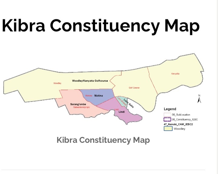
Kibra is a constituency located in the southwestern part of Nairobi, bordered by Lang’ata, Dagoretti North, Dagoretti South, and Starehe Sub-counties. Established from the former Lang’ata and Dagoretti districts in 2013, Kibra covers only 12.1 km². Today, Kibra has five administrative wards—Sarang’ombe, Woodley/Kenyatta Golf Course, Makina, Laini Saba, and Lindi—with about 185,777 Residents. Kibra postal codes fall within the 00100–00625 range.
Embakasi East
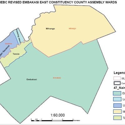
Embakasi East is a constituency in Nairobi County covering 64.7 km² of southeastern Nairobi, stretching from the Eastern Bypass to the Athi Plains. It was formed from the larger Embakasi Constituency in 2013. Administratively, it comprises five wards—Upper Savannah, Lower Savannah, Embakasi, Utawala, and Mihango—and forms part of Nairobi’s most densely populated sub-county, with postal codes spanning 00501 (JKIA) to 00521 (Embakasi Village).
Embakasi West
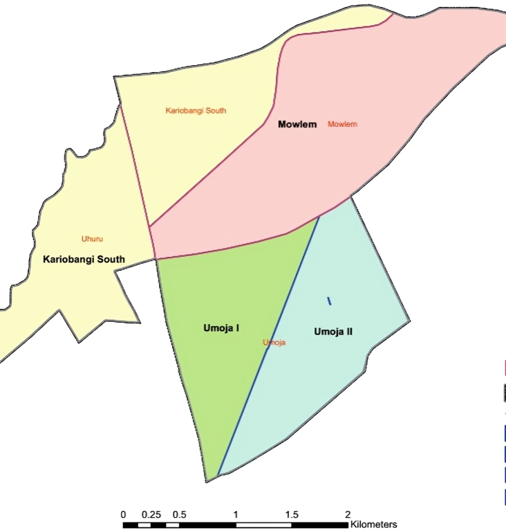
Embakasi West is a constituency in Nairobi County formed from the larger Embakasi Constituency and parts of Kamukunji in 2013 and covers only 9.35 km² of Nairobi’s Eastlands. The constituency has four wards—Umoja I, Umoja II, Mowlem, and Kariobangi South- with Postal code ranges between 00500 and 00521.
Embakasi Central
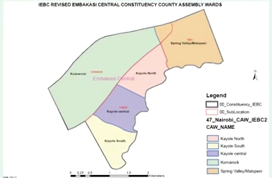
Embakasi Central is a constituency in Nairobi County located 15 kilometers southeast of the city center. Like all other Embakasi constituencies, it was formed from the larger Embakasi Constituency in 2013 during Kenya’s devolution reforms. Administratively, it comprises five wards—Kayole North, Kayole Central, Kayole South, Komarock, and Matopeni/Spring Valley, with postal codes ranging from 00501 to 00518.
Embakasi North
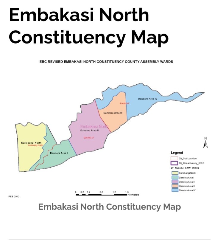
Embakasi North is in the eastern part of Nairobi. Its origins are traced back to the broader Embakasi region, once a colonial-era detention camp during the Mau Mau uprising. The Embakasi North was formed from the former Embakasi Constituency in 2013 and has five wards: Kariobangi North and Dandora Areas I to IV, with postal codes of 00516.
Embakasi South
Embakasi South is a sub-county and constituency in Nairobi County, located southeast of the central business district. Historically, it was a pre-colonial center for the trading activities between the Maasai and Kamba communities, but its modern shape was facilitated by the establishment of Embakasi Airport (now Jomo Kenyatta International Airport) in 1958. Currently, it was formed from the larger Embakasi constituency in 2013, it now comprises five wards—Imara Daima, Kware, Kwa Reuben, Kwa Njenga, and Pipeline, with a Postal code of 00501.
Kasarani
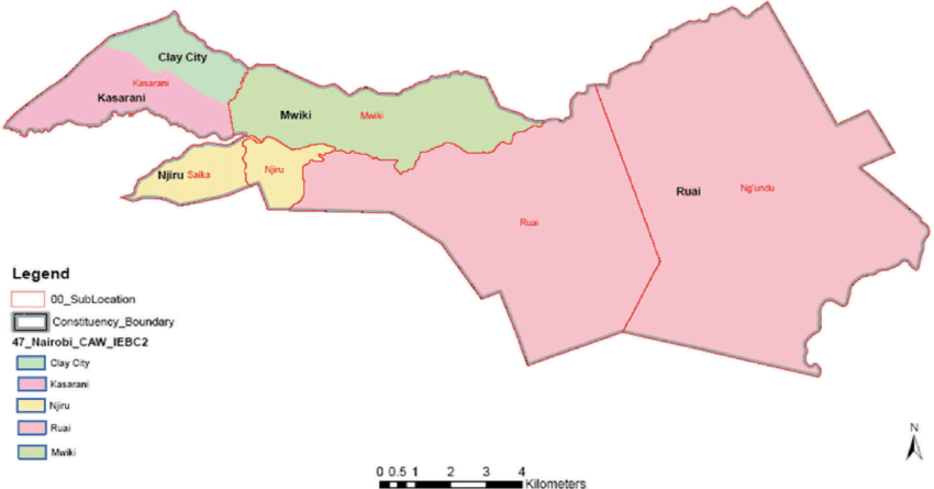
Kasarani is a constituency in Nairobi located in the northeastern part of the county, stretching 152.6 km². It borders Roysambu to the west and Embakasi North to the southeast. It was part of the Nairobi Northeast Constituency in 1963 before evolving into Mathare Constituency and later splitting into its current form during Kenya’s 2010 devolution reforms. Administratively, Kasarani Sub-County encompasses five wards—Kamulu, Njiru, Clay City, Mwiki, and Ruai, with postal codes of 00608
Ruaraka
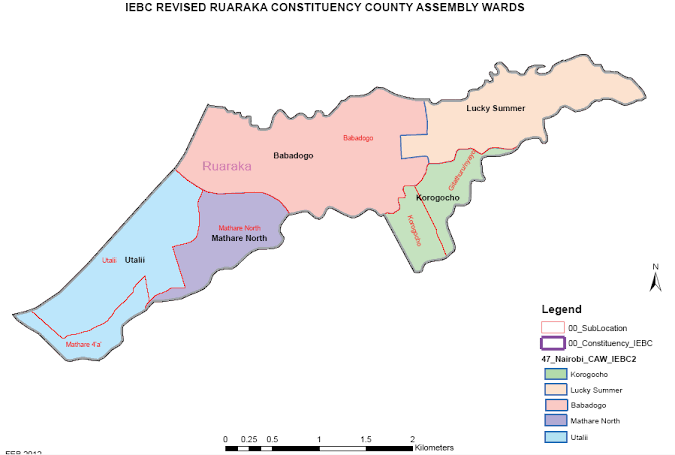
Ruaraka is a sub-county located 8 kilometers northeast of Nairobi’s central business district. It was formed from the former Kasarani Constituency in 2013 to mitigate electoral tensions; however, its origins trace to 1922, when Welsh entrepreneurs established Kenya Breweries along the Rui-Rwa-Aka river, a site historically reserved for Kikuyu initiation rites. Administratively, Ruaraka has five wards—Baba Dogo, Utalii, Mathare North, Lucky Summer, and Korogocho, with postal codes of 00618.
Kamukunji
Kamukunji is a sub-county located on the eastern side of Nairobi County. It covers 8.8 km² and is bordered by Starehe, Makadara, Embakasi West, and Mathare. Its roots trace back to 1963, when it emerged as Nairobi Central Constituency. Later, after boundary revisions that split the former Pumwani Division, the sub-county was renamed in 2013. Administratively, the sub-county comprises five wards: California, Eastleigh North, Eastleigh South, Airbase, and Pumwani, with postal codes ranging from 00610 to 00619.
Makadara
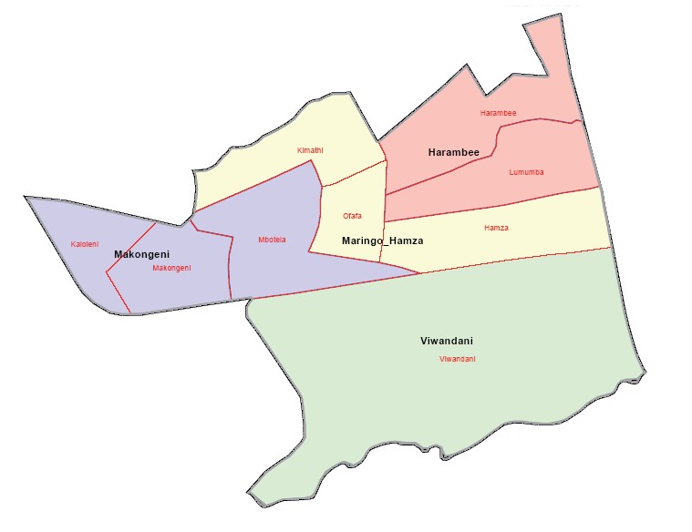
Makadara is a densely populated area of Nairobi City County covering 11 km². It has six wards: Maringo/Hamza, Viwandani, Harambee, Makongeni, Mbotela, and Bahati. The postal codes range from 00500 (Enterprise Road) to 00522 (Makadara Central).
Starehe

Starehe is a sub-county in Nairobi County. It was originally inhabited by Maasai pastoralists and Kikuyu agriculturalists drawn to its cool springs, the source of its name meaning place of cool waters in Maa. Today, the sub-county covers 11 km² and has one Constituency, Starehe, with six wards: Nairobi Central, Ngara, Pangani, Landimawe, South B, and Ziwani/ Kariokor. Postal codes range from 00100 (Nairobi GPO) to 00600 Ngara Road.
Mathare
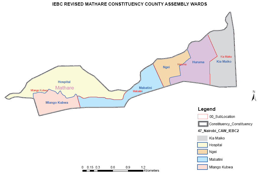
Mathare is a densely populated informal settlement in Nairobi’s Eastlands, covering 3.0 km² and is bordered by Pangani to the west, Juja Road to the south, and Huruma to the east. Administratively, Mathare is made up of two constituencies—Mathare and Ruaraka, with 6 electoral wards, namely Hospital, Mabatini, Huruma, Ngei, Mlango Kubwa, and Kiamaiko. Mathare’s Postal code is 00611.
Roysambu
Roysambu is a sub-county in Nairobi County whose origins date back to the early 20th century, when Australian settler Henry Tarlton established the 4,443-acre Roysambu Estate in 1904. Administratively, Roysambu became a constituency in 2013 after splitting from Kasarani. It now governs five wards: Roysambu, Zimmerman, Githurai, Kahawa, and Kahawa West.