
Kabiro Ward Postal Code 00603 (Dagoretti North): All Areas
Quick Answer:
- Postal Code(s): 00603 and 00100
- Sub-County: Dagoretti North, Nairobi City County
- Location: Western Nairobi, within the larger Dagoretti area
- Area: Approximately 1.2 km²
- Population (2019/est.): About 34,700 residents
- Ward Type: Urban, high-density, predominantly low- and middle-income residential
- Main Areas: Kabiro and Muslim sub-locations, Jamhuri area (nearby), Kabiria/Kabiria Road corridor, and parts of Kawangware-adjacent neighborhoods that are administered within Kabiro Ward
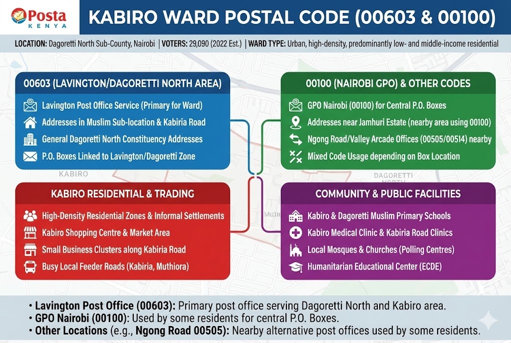
Kabiro Ward uses postal codes 00603 and 00100 because it lies in Dagoretti North Sub-County in western Nairobi and is generally served by the broader Lavington/Dagoretti North postal zone and the Nairobi GPO system. The ward covers about 1.2 square kilometres with an estimated population of roughly thirty-four thousand residents. Kabiro sits between other Dagoretti North wards such as Kawangware and Gatina, and is close to areas like Jamhuri Estate and Waithaka in neighbouring constituencies.
Neighboring Wards & Boundaries
| Direction | Neighboring Ward/Area | Sub-County | Postal Code |
|---|---|---|---|
| North | Parts of Kileleshwa / Kilimani area across Dagoretti North boundary | Dagoretti North | 00603 (Lavington/Kilimani area), 00100 (GPO Nairobi) |
| South | Jamhuri Estate and neighbouring areas towards Kibra/Ngong Road | Nearby Kibra / Dagoretti sub-counties | 00505 (Ngong Road corridor), 00100 |
| East | Kawangware Ward and Kawangware/Kabiria corridor | Dagoretti North | 00515 (Buruburu–wider Nairobi residential), 00603 (Lavington/Dagoretti North) |
| West | Gatina Ward and Waithaka/Dagoretti South fringe areas | Dagoretti North and Dagoretti South | 00613 (Waithaka), 00605 (Uthiru/Dagoretti) |
Postal Codes For Kabiro Ward (Dagoretti North)
| # | Ward/Area | Location / Facility | Postal Code | Type |
|---|---|---|---|---|
| MAJOR AREAS & LANDMARKS | ||||
| 1 | Kabiro | General Kabiro residential area within Dagoretti North | 00603 | Residential |
| 2 | Muslim Area | Muslim Sub-location residential zone in Kabiro Ward | 00603 | Residential |
| 3 | Kabiro | Kabiro shopping and market area along Kabiria Road | 00603 | Commercial/Residential |
| 4 | Kabiria/Kabiria Road | Estates and plots along Kabiria Road serving Kabiro residents | 00603 | Residential |
| 5 | Jamhuri (nearby) | Jamhuri area close to Kabiro and Dagoretti North | 00100 | Residential (nearby) |
| 6 | Kabiro | Ward offices and local administration area | 00603 | Administrative |
| MAJOR ROADS & ACCESS | ||||
| 7 | Kabiria/Kabiro | Kabiria Road corridor serving Kabiro residents | 00603 | Transport |
| 8 | Kabiro | Muthiora Road (rehabilitated under Nairobi County projects) | 00603 | Transport |
| 9 | Muslim–Kabiro | Muslim–Gotham Road upgraded within Kabiro Ward | 00603 | Transport |
| 10 | Kabiro/Jamhuri | Local access roads linking Kabiro to Jamhuri Estate | 00100 | Transport |
| 11 | Kabiro | Internal estate roads around Kabiro Primary area | 00603 | Transport |
| COMMERCIAL & MARKETS | ||||
| 12 | Kabiro | Local retail centres and kiosks near Kabiro shopping centre | 00603 | Commercial |
| 13 | Kabiria Road | Small business clusters along Kabiria Road (shops, services) | 00603 | Commercial |
| 14 | Jamhuri (nearby) | Jamhuri trading and market area serving Kabiro residents | 00100 | Commercial (nearby) |
| 15 | Kawangware edge | Informal trading points on Kabiria/Kawangware edge serving Kabiro | 00603 | Commercial |
| SCHOOLS & EDUCATION | ||||
| 16 | Kabiro | Kabiro Primary School | 00603 | School |
| 17 | Kabiro | St Anthony Mixed High School (Kabiro polling station list) | 00603 | School |
| 18 | Kabiro/Muslim | Dagoretti Muslim Primary School | 00603 | School |
| 19 | Kabiro | HGM Primary School, Riruta (used as Kabiro polling station, serving Kabiro learners) | 00603 | School |
| 20 | Kabiro | Humanitarian Educational Center (Kabiro entry in ECDE directory) | 00603 | School/ECDE |
| 21 | Kabiro/Muslim | Local ECDE centres attached to primary schools in Kabiro Ward | 00603 | ECDE |
| HEALTHCARE FACILITIES | ||||
| 22 | Kabiro | Kabiro Medical Clinic (listed in national health facility registry; matches Kabiro name) | 00603 | Health |
| 23 | Kabiria Road | Small private clinics along Kabiria Road serving Kabiro residents | 00603 | Health |
| 24 | Jamhuri (nearby) | Clinics in Jamhuri area used by Kabiro residents | 00100 | Health (nearby) |
| RELIGIOUS CENTERS | ||||
| 25 | Kabiro/Muslim | Dagoretti Muslim area mosques and Islamic centres | 00603 | Religious |
| 26 | Kabiro | Local Christian churches around Kabiro Primary and Kabiria Road | 00603 | Religious |
| 27 | Jamhuri (nearby) | Churches in Jamhuri serving worshippers from Kabiro | 00100 | Religious (nearby) |
| RECREATION & COMMUNITY | ||||
| 28 | Kabiria/Kabiro | Community fields and play areas along Kabiria Road | 00603 | Recreation |
| 29 | Jamhuri (nearby) | Jamhuri grounds and open spaces used by Kabiro residents | 00100 | Recreation (nearby) |
| POSTAL SERVICES | ||||
| 30 | Lavington Post Area | Lavington post zone serving Dagoretti North, including Kabiro Ward addresses via code 00603 | 00603 | Postal service area |
| 31 | Nairobi GPO | General Post Office Nairobi used by some Kabiro residents and businesses | 00100 | Post Office |
| 32 | Ngong Road/Valley Arcade (nearby) | Post offices along Ngong Road corridor used by some Dagoretti residents | 00505/00514 | Alternative post offices (nearby) |
Frequently Asked Questions
Kabiro Ward commonly uses postal code 00603 because it falls within the broader Lavington/Dagoretti North postal area served by that code. However, some residents and businesses also use the general Nairobi GPO code 00100 on their addresses, especially where P.O. Boxes are registered at the central post office rather than a local branch.
The code 00100 belongs to the General Post Office in central Nairobi and is widely used as a default city postal code, including by people living in areas like Kabiro
Kabiro Ward includes Kabiro and Muslim sub-locations and is closely associated with the Kabiria Road corridor and neighbouring areas near Jamhuri Estate and parts of Kawangware